We packed up and headed on Highway 75 past the Sawtooth Mountains and towards Craters of the Moon National Monument.
We stopped off at Ketchum for a break and had a beer at the Warfield Distillery and Brewery. Ketchum is a ski resort in the winter and we enjoyed sitting on the deck in the sun looking up at the ski runs and lifts.
When we reached Craters of the Moon, the landscape changed dramatically from fields full of crops and animals in front of picturesque mountains to flat black lava fields as far as the eye could see.
The campsite was FCFS so we went and found a nice site with some protection from the wind and big enough for our tent, pitched and the headed to the Experimental Breeder Reactor-1 (EBR-1) which was only a 30 minute drive away.
EBR-1 is a decommissioned research reactor and U.S. National Historic Landmark. It was the world's first breeder reactor and on December 20, 1951, it became one of the world's first electricity-generating nuclear power plants when it produced sufficient electricity to light four 200-watt light bulbs. It was really interesting walking around the site and the equipment learning more about nuclear energy and the history of our nuclear power plants today. Outside the museum there were two more reactors on show but these ones were designed for aircraft as part of a $7 billion initiative in the 50's. After the two reactors were built and tested a couple of times, the programme was terminated during Kennedy's presidency. Maybe that was a good thing, I'm not sure how comfortable I would feel having nuclear reactors flying around our skies.
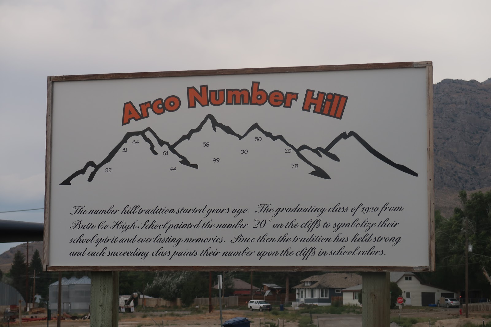
We headed back to Craters of the Moon, driving through a small town called Arco. There are less than a 1000 people little in Arco yet this little town has an interesting character! On the sides of the mountains surrounding the town are numbers. Initially we thought it must be something to do with the nuclear research facility down the road but we eventually found out from a sign in town that it was graffiti from school children! Every year since 1920, high school graduates climb the mountains and mark the last two digits of the graduation year. To start with, I found it interesting and tried to find each of the year but by the end of our time in Arco, I was starting to see it as a little ugly on the landscape.

The numbers on the mountains are not the only interesting thing in Arco, there is also a Science Center. The building is only the same size as a car but it does document the Nuclear history of this little town, including it being the world's first town to be completely nuclear powered (by the ERB-1). There is a fin from a submarine outside the Science Center which we thought was a little odd given we were in a desert and many miles away from any sea shore but we found out that Arco was where nuclear propulsion for submarines began. During the Cold War, this tiny little town in the middle of nowhere was the place in the USA for nuclear testing and investigation but their work was so classified, no one knew about, only now are some of the details coming out.
The lab still exists today and continues to research nuclear energy as well as continuing to remove and control thousands of tons of radioactive and hazardous waste from across on the country. On that note, we decided we'd better head out of Arco and back to Craters of the Moon!
We had a few hours of the afternoon left so we headed into Craters of the Moon National Monument and Preserve to explore.
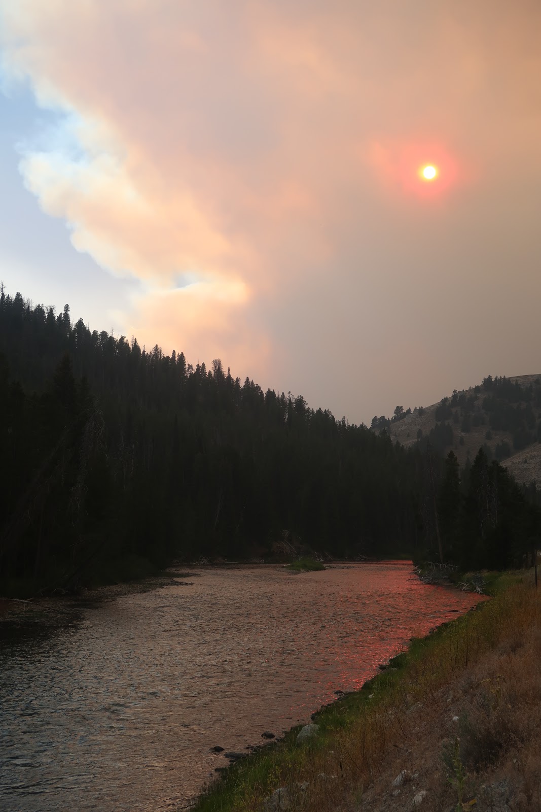
Craters of the Moon received its name in 1923 when geologist Harold T. Stearns called the landscape "the surface of the moon seen through a telescope" but unlike the moon, this landscape was created mainly from lava flow rather than meteorites. Unlike the volcanic areas we have seen before, the lava is not from a volcano but from huge fissures in the ground, know as the Great Rift. The last eruption was only 2,000 years ago and scientist are predicting future eruptions are very likely!
We traveled around the park loop road, a 7 mile drive with 7 stops all of which teach you something about the features and the history of this area. We enjoyed the visitors center where we learnt more about volcanic fissures and then we did the 0.3 mile trail around the North Crater Flow which information stations explaining the different types of lava. The Devils Orchard 0.5 mile hike was through a lava area where the vegetation was starting to grow, it was like being in a strange garden. During this hike, we learnt about the impact humans were having on the park and how the park service was trying to protect it today. The hike up Inferno Cone was only supposed to be 0.2 miles but it was a steep gradient and for some reason, we decided to race up it. Half was up, we realised what a huge mistake this was. Lee won of course, but only because I gave up near the top to video him! Our last stop was at the splatter cones. These are some of the areas along the rift where the lava came out. They look like little volcanoes and there was a trail to walk up the side of two of them and look down into the hole.
We spent about 2 hours on the drive and had the weather been a little better, we could have spent a lot longer doing some of the more difficult hikes but a storm was coming in and we needed to get back to the campsite to get ready for it!
No wood fires are allowed in Craters of the Moon but charcoal is allowed so Lee cooked up some steaks on the BBQ which we had in sandwiches. We had just finished dinner when the wind started to get stronger and the rain came in. We checked the tent was secure and then headed inside. The campsite at Craters of the Moon is very exposed, there are very few trees and rocks to hide your tent behind to protect it from the wind. We were lucky to get one of the view sites with some protection. That night, the wind was really strong, we saw one set of campers retreating to their car as their tent was being flattered by the wind. Our tent held up well, much better than it did in Monument Valley, we had tied it down with every piece of rope had on us but the noise did make it difficult to sleep.